Our services

Drone Surveys: High-Precision Traffic Data Collection

Our Drone Survey services provide a cutting-edge solution for collecting accurate, real-time traffic data tailored to your project needs.
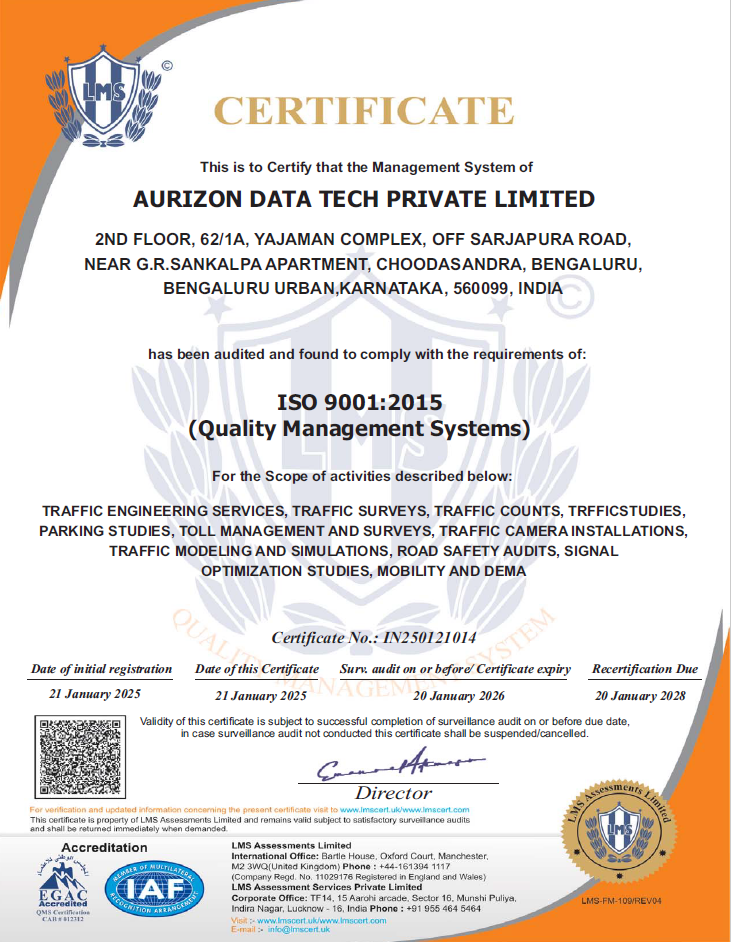
Quality

Guaranteed

Drone Surveys offer a revolutionary approach to traffic data collection, delivering precise insights into traffic flow, congestion points, and road usage. By capturing high-resolution aerial data, these surveys provide an unparalleled view of traffic dynamics, enabling accurate analysis for infrastructure planning, traffic management, and safety assessments. Drone technology ensures comprehensive coverage and scalability, making it ideal for projects of all sizes. Drone Surveys provide a comprehensive and innovative method for observing traffic trends, delivering invaluable insights that traditional methods often miss.

  • Precise Aerial Analysis
    Drone Surveys deliver detailed traffic flow insights, identifying congestion points and optimizing road use.

  • Informed Decision-Making
    Comprehensive aerial data supports infrastructure design and efficient traffic management strategies.

  • Enhanced Safety and Efficiency
    Using drones, we ensure high accuracy, enabling safer and more effective planning for traffic systems.

Seamless Traffic Count Consultation

Our traffic count consultation service ensures that every insight we provide is in perfect harmony with your strategic goals. By delivering accurate, actionable data, we help optimize your traffic management efforts, empowering you to make informed decisions for better planning and growth.

Our services

Other services we offer

Turning Movement Counts

Precise data on vehicle movements at intersections.

Round-about Counts

Detailed traffic flow analysis for roundabouts.

Queue Length

Measuring traffic queues for congestion insights.